Before the Boundary Line: Why Neighbouring Places Keep Distinct Names
Learn how neighboring place names can preserve older settlement and administrative patterns, and how to read them without mistaking a clue for a complete history.
The common mistake when reading a local map is to treat a boundary as the beginning of a place’s identity; the cost is missing the older names and attachments that remain visible on either side. Neighboring place names can preserve traces of settlement and administration even after the line between them changes. A name is a useful clue, not a complete account.
Start with the names that the boundary does not explain
Choose a small area you know: perhaps two neighboring villages, districts, or town neighborhoods. Write down the names used for the places on either side of their current boundary, including names on street signs, bus stops, parks, and local maps. Notice whether a name refers to a whole settlement, a smaller neighborhood, or a feature such as a hill or stream.
Keep the terms distinct. A settlement name may be older than the present administrative unit that uses it. Conversely, a district may have a formal name that residents rarely use in ordinary conversation. Both are part of regional character, but they do not necessarily describe the same thing.
For this first pass, avoid deciding what a name means. Record its spelling and where you encountered it. Small differences—an older spelling on a sign, or a name attached to a road rather than a whole neighborhood—can point to different layers of use.
Give the week a simple rhythm
Spread the inquiry across a week so that maps, place names, and local observations can be compared without forcing them into one story. A notebook or a simple digital document is enough. Keep a separate note for each source, along with the date you consulted it and the exact wording it uses.
- Day one: List the neighboring place names and mark which ones appear in everyday speech, on signs, or in official map labels.
- Day two: Look at a current local map and note the present boundary, nearby roads, streams, rail lines, and named settlements.
- Day three: Compare an older map, if one is available through a local library, archive, or map collection. Record names and boundaries separately rather than assuming they changed together.
- Day four: Check local government pages or directories for the names of present administrative areas. Note which body uses each name and what area the name refers to.
- Day five: Walk or travel through the area, if practical, and notice where names appear on signs, transit information, and public notices. Do not infer a boundary from a sign alone.
- Day six: Compare the notes and mark what is directly visible, what is documented by a source, and what remains a possibility.
- Day seven: Write a short account that separates the evidence from your interpretation. Leave unresolved questions open rather than smoothing them into a single history.
That sequence is a way to slow down interpretation, not a research requirement. If the week is busy, the most useful habit is simply to keep each source’s claim attached to that source.
Read settlement and administration as different layers
Older settlement patterns often show up in names that persist after streets, land uses, or population centers have shifted. A name may remain attached to a crossroads, a cluster of houses, or a landscape feature, even when an administrative boundary now cuts across the area. Persistence does not tell you exactly when the name began or who first used it.
Administrative names answer a different question: which unit is responsible for a service, a record, or a local decision now? Their boundaries can be revised while familiar settlement names remain. A map that shows both layers can help explain why two nearby places have distinct names without suggesting that the current line created those identities.
Compare sources with care. An older map may use a label for a hamlet that does not appear in a present-day directory; a directory may list an official area name not used by local residents. Neither source automatically cancels the other. They may be describing different periods or purposes.
Keep a clue separate from a conclusion
Say you notice that two neighboring places have distinct names, and an older map labels one of them as a small settlement while a newer administrative map places both within a changed local unit. You could record the observable result: the settlement label appears on the older map, while the newer map uses a different administrative arrangement. It would be a further, unproven claim to say exactly why the boundary changed or that the name records the full history of the settlement.
That distinction matters because names can be borrowed, altered, revived, or applied differently over time. A shared word in two place names may suggest a connection, but it could have several explanations. Local naming habits also do not always align neatly with formal records.
When a source’s date, purpose, or naming convention is unclear, say so in your notes. If you consult a historical map or local record, follow its catalog description and any guidance from the holding library or archive; use local rules for access where they apply.
What can a place name tell you?
Does a place name reveal who settled there first?
Not by itself. A name can preserve an older pattern of settlement, but it may have been changed, transferred, or recorded long after people began using it.
Why do neighboring places keep different names after a boundary changes?
Names can remain part of local speech and signs even when administration is reorganized. A present boundary and a familiar place name describe different layers of local identity.
Which source should I trust for an older boundary?
Start with a dated map or record that clearly identifies what it depicts, then compare it with other sources where possible. Treat differences as evidence to examine, not as an automatic reason to choose one account.
Can a name tell me where one community ends?
A name may suggest how people distinguish places, but it does not establish a precise social edge. Residents may use overlapping names, and official lines may not match everyday descriptions.
Leave room for more than one local story
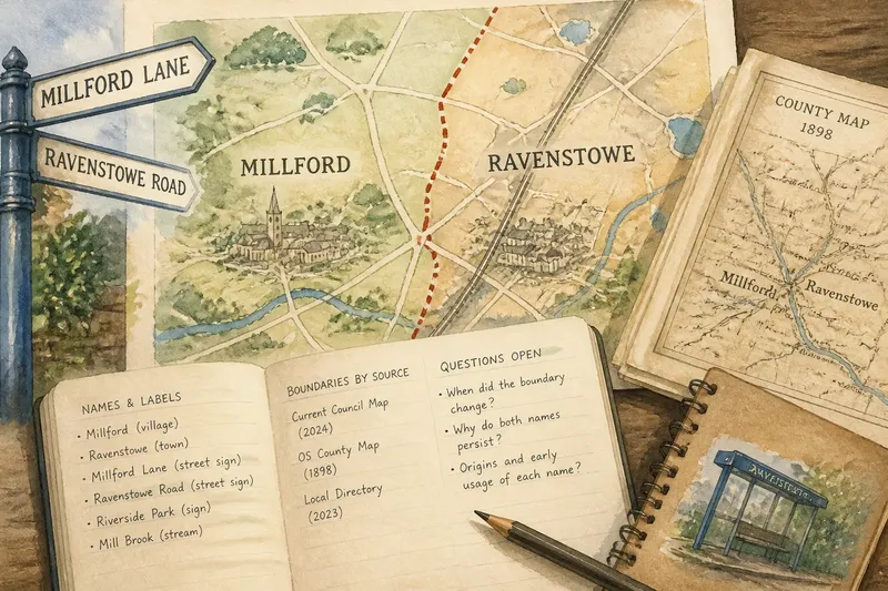
At the end of the week, arrange your notes in three columns: names and labels, boundaries shown by each source, and questions still open. This makes it easier to explain what the material supports without turning a suggestive clue into a confident origin story.
The main search for why neighboring places keep distinct names often begins with a map, but the clearest answer comes from comparing what maps, records, signs, and local usage each actually say. A place name can carry the trace of an older settlement or administration while leaving much of its history untold. Keep that gap visible; it is part of reading regional character honestly.